


History of GIS
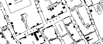
The Cholera Outbreak
A cholera outbreak hit the city of London, England. British physician John Snow began mapping cholera locations, roads, property boundaries, and water lines. John Snow performed one of the first mapping overlays in history. He overlaid water pump locations with cholera cases. By doing mapping overlays, he found a connection between water pump locations and cholera cases. This historic moment in GIS led to the creation of the field of epidemiology.